
14-day Eastern Caribbean (Carnival Journeys)
Route: Galveston, Key West, Celebration Key, San Juan, St. Thomas, St. Kitts, St. Maarten, St. Croix, Ocho Rios, Galveston
From $1,405 (USD)
Charlotte Amalie cruises from Galveston visit St. Thomas. Plan your arrival at Havensight, Crown Bay or a tender landing, then choose historic town streets or a beach outing.
Your landing shapes the day: connect with downtown for Fort Christian, shops and lunch, or arrange a road transfer to Magens Bay with a return to the correct cruise facility.
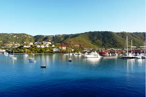
Browse Charlotte Amalie cruises out of Galveston, Texas. Compare complete itineraries and sailing details, then plan your St. Thomas visit around the ship’s arrival and boarding instructions.
Use the filters below to narrow the current cruise results.
Route: Galveston, Key West, Celebration Key, San Juan, St. Thomas, St. Kitts, St. Maarten, St. Croix, Ocho Rios, Galveston
From $1,405 (USD)
Charlotte Amalie cruises from Galveston bring you to St. Thomas, where the historic harbor town and the cruise terminal may be separate parts of your day. Start with the Charlotte Amalie cruise schedule, then use your ship’s arrival instructions to identify Havensight, Crown Bay or a tender landing. The destination name alone does not tell you where you will step ashore.
Havensight is the West Indian Company, or WICO, dock at Long Bay. Shops around the terminal provide a local starting point; downtown lies farther around the harbor. Walking toward town via the Yacht Haven Grande area and waterfront is an option if that additional walk suits your group. Ask port staff about the pedestrian exit and current route before leaving. A taxi lets you save your walking for the old streets and hills.
Crown Bay is the Austin “Babe” Monsanto Marine Terminal, west of Charlotte Amalie Harbor. Its own commercial complex has shopping and dining, and taxis serve the facility. For a downtown visit, a taxi connection is a practical starting plan. Havensight walking directions do not describe the route from Crown Bay.
If the ship anchors and uses tenders, record the actual shore landing and the ship’s return-boat instructions. Boarding the small boat and reaching shore are additional stages before an independent outing or excursion meeting. Ask the cruise line about the transfer arrangement if steps or changing boarding conditions affect your ability to participate.
Once downtown, the waterfront, Fort Christian, Emancipation Garden, Main Street and Palm Passage give you a compact area to explore. You can spend the visit on harbor views, old buildings, shops and lunch without traveling across the island. The U.S. Virgin Islands guide puts this St. Thomas visit in context alongside the territory’s other island experiences.
Fort Christian’s red walls are a useful landmark near the harbor. Its museum offers context for Danish colonial rule, maritime trade, slavery and emancipation. Nearby Emancipation Garden adds another place to pause and consider that history. For an interior visit, use the fort’s current visitor information for admission and accessible areas; looking at the building from outside does not provide the museum experience.
Main Street and Palm Passage suit browsing at your own pace, with a meal woven into the walk. Caribbean dishes such as conch fritters, curry goat or jerk chicken can make lunch part of the visit; choose from the menu offered by the restaurant you select. A courtyard or harbor-side meal also gives you a reason to shorten the shopping circuit instead of adding another attraction.
The historic 99 Steps add a different physical task. This is a climb up a step street, not a continuation of a level waterfront stroll. Include it if stairs fit your group’s plans, or keep the route around the lower town. Reaching the top should not be treated as a promise of entry to another attraction. You can enjoy the town’s architecture and harbor setting without making the climb.
An organized history walk can add interpretation of the streets and buildings. Its booking should identify the actual walking route, any admitted interiors and where the guide leaves you. An independent circuit lets you stop sooner or spend longer over lunch, but you arrange the connection back to your cruise facility yourself.
Magens Bay is on St. Thomas’s north coast, reached by road across the island. Make the sandy shore and time by the water the main outing if that is what you want from the call. This beach visit adds a vehicle connection in both directions; it is separate from the downtown walking area. The St. Thomas island guide compares Magens Bay with scenic outings and Coral World for travelers choosing among broader island experiences.
The beach authority lists food and drink vendors, chair rentals and a taxi stand. Admission, rentals and purchases have their own terms. For an independent trip, agree on the outbound fare and destination, then establish how and where you will obtain the return ride. Tell the driver whether you need Havensight, Crown Bay or your tender landing.
A paid beach transfer can simplify those connections. Carnival’s representative Magens Bay Beach Express lists round-trip transportation and beach entrance, with time at the beach without a guided activity component. Food, drinks and rental items need their own budget. The option illustrates an experience to compare in your cruise’s excursion listings; it does not establish an offering on every sailing.
Count the road journey and any scenic stop separately from time on the sand. A beach-and-viewpoint title may include a brief stop above the bay, while the beach remains the principal activity. The representative transfer travels on steep, winding roads and requires walking over uneven ground and sand; its mobility restrictions matter even though much of the journey is by vehicle. Obtain the operator’s participation details before selecting it. Hiring a taxi independently also requires a vehicle and walking arrangement that works for your group.
For current park services and admission information, consult the Magens Bay Authority. Decide whether you want beach time or a fuller town visit, then add the other only if your ship’s call leaves room for both.
“Back to the port” needs a precise destination in Charlotte Amalie. From downtown or Magens Bay, your return may end at Havensight, Crown Bay or the agreed tender landing. Keep that location with your ship’s contact information. A tour ending in town leaves another connection; a taxi reaching the terminal still leaves the entrance and route to the gangway.
For a tender call, follow the ship’s final shore-to-ship boarding instructions and allow for waiting at the landing. For a docked call, leave time for the terminal approach and boarding. Use the ship’s time and all-aboard instructions when arranging either return, with room for changes in road travel or the transfer process.
On a cruise out of Galveston, Texas, the Eastern Caribbean itinerary guide helps you balance this shore day with the other stops. Choose Charlotte Amalie for town and history, or use it as your gateway to an island outing. The complete itinerary and dynamic schedule supply the sailing details that shape that choice.
Compare typical temperatures and monthly rainfall at this port. These climate averages are not the forecast for a particular sailing.
Daytime highsNighttime lows
Each colored mark shows a monthly average for this port. Rainfall figures are monthly totals at individual locations, not a regional sum or the number of rainy days.
Season labels describe the annual climate pattern. They do not predict whether a specific cruise will encounter a storm.
Climate period: 1992-2021 air-climate averages; supplementary long-term rainfall-day, sunshine, UV and 10-year marine averages
Data basis: Timeanddate (Cyril E. King Airport); Weather2Travel; SeaTemperature.info
Dataset verified: 2026-09-10
| Month | Highs (°F) | Lows (°F) | Rainfall (in) | Sea (°F) | Humidity | Cyclone season |
|---|---|---|---|---|---|---|
| January | 84.0 | 73.0 | 2.8 | 80.1 | 72% | Outside season |
| February | 84.0 | 73.0 | 2.2 | 79.5 | 71% | Outside season |
| March | 84.0 | 73.0 | 2.1 | 79.5 | 70% | Outside season |
| April | 86.0 | 75.0 | 2.4 | 80.4 | 71% | Outside season |
| May | 87.1 | 77.0 | 3.5 | 81.7 | 73% | Outside season |
| June | 89.1 | 79.0 | 3.0 | 82.9 | 71% | Low |
| July | 90.0 | 79.0 | 3.9 | 83.3 | 71% | Low |
| August | 90.0 | 79.0 | 4.6 | 84.2 | 73% | Elevated |
| September | 89.1 | 79.0 | 5.6 | 84.7 | 75% | Peak season |
| October | 88.0 | 78.1 | 6.0 | 84.7 | 75% | Peak season |
| November | 86.0 | 75.9 | 6.3 | 83.5 | 75% | Declining |
| December | 84.9 | 75.0 | 3.3 | 81.7 | 73% | Outside season |
Compare sailing dates, cruise lines, ships, lengths, and travel options for these itineraries.
Choose a year or month to see departure dates for Charlotte Amalie cruises from Galveston.
Compare the cruise lines and ships currently scheduled on these itineraries.
Compare the cruise lengths available in the current schedule.
Explore itinerary types, seasons, holiday travel windows, and special programs in the current schedule.