

December Caribbean Cruise Weather
December begins the winter pattern for Galveston cruises. Caribbean ports remain warm, but the Gulf Coast and northern Bahamas may be cooler or windier than destinations farther south.
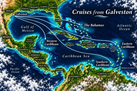
Caribbean cruise weather changes through the year, but it also varies by region. Use this guide to compare monthly conditions for cruises from Galveston, then open a month guide for more detail about the Gulf, Western Caribbean, Bahamas, and longer Caribbean routes.
A month guide provides climate context rather than a forecast for a particular departure. It explains the conditions that are more typical for that time of year, the regional differences that matter on Galveston itineraries, and the weather questions to revisit when the sailing date is closer.
The calendar changes several parts of a cruise at once. Temperature and humidity affect time outdoors, rainfall patterns influence port-day planning, and tropical-weather monitoring becomes more important during the Atlantic hurricane season.
The official Atlantic hurricane season runs from June 1 through November 30, with most tropical cyclone activity occurring from August through October. Those dates describe a broad climatological pattern, not the conditions that a specific cruise will encounter. A system elsewhere may change a port call, travel to Galveston, or conditions in the Gulf even when a sailing still departs.
Rainfall also needs regional context. Galveston, Mexico, Belize, Honduras, the Bahamas, and islands farther east or south do not share one identical wet-season calendar. A forecast for the departure port cannot describe an entire itinerary, and a rain symbol for a tropical destination may represent a passing shower rather than continuous rain.
Winter brings a different planning balance to cruises from Galveston. Caribbean destinations remain warm compared with the Gulf Coast, but wind, passing fronts, and cooler conditions in Galveston or the northern Bahamas can affect the first and last parts of the trip.
For actual departures and itinerary choices, see Winter cruises from Galveston.
December begins the winter pattern for Galveston cruises. Caribbean ports remain warm, but the Gulf Coast and northern Bahamas may be cooler or windier than destinations farther south.

January combines winter conditions along the Gulf Coast with warmer weather farther south. Compare wind, cooler northern-route conditions, and regional rainfall before choosing a beach- or excursion-focused itinerary.

February retains the winter contrast between Galveston, the northern Bahamas, and warmer Western Caribbean destinations. The route matters when comparing temperatures, wind, and time planned around the water.
Spring sits between the cooler winter pattern and the hotter, wetter part of the year. March, April, and May do not have identical conditions, so the monthly guides separate changes in heat, humidity, rainfall, and school-break travel.
For actual departures and itinerary choices, see Spring cruises from Galveston.

March begins the spring transition and overlaps common spring-break travel dates. Conditions are generally warmer than in midwinter, while humidity and rainfall still vary substantially by destination.

April sits between the cooler winter pattern and the hotter, wetter part of the year. It is useful for comparing warm port days with lower tropical-weather exposure than the official hurricane-season months.

May brings rising heat and humidity across many Galveston cruise routes. Rainfall becomes a more important planning factor in some destinations even though the Atlantic hurricane season has not officially started.
Summer cruises combine high temperatures, stronger humidity, school-break demand, and more time spent around pools, beaches, and water excursions. June also begins the Atlantic hurricane season, while August enters its more active climatological period.
For actual departures and itinerary choices, see Summer cruises from Galveston.

June starts the Atlantic hurricane season and the summer-break period. High temperatures, humidity, passing showers, and outdoor exposure matter when comparing port activities and ship features.

July is firmly within the hot and humid summer pattern. Hurricane season is underway, but summer heat, sun exposure, showers, and school-break demand may be the more immediate planning factors.

August combines summer heat and humidity with the beginning of the climatologically more active part of Atlantic hurricane season. Travelers should compare route flexibility as well as beach, excursion, and sea-day plans.
Fall requires the clearest distinction between climate context and a forecast for one sailing. September and October fall within the climatologically active part of hurricane season, while November remains inside the official season through the end of the month but has a different typical risk profile.
For actual departures and itinerary choices, see Fall cruises from Galveston.

September falls near the climatological peak of Atlantic hurricane activity. A cruise is not defined by that risk alone, but flexible transportation, itinerary expectations, and close weather monitoring become more important.

October remains within the more active part of hurricane season, while heat and rainfall vary by region. Conditions should be checked for the Gulf and each port instead of using one Caribbean-wide forecast.

November remains within hurricane season through the end of the month, but it does not have the same typical profile as September. Gulf fronts, wind, holiday travel, and destination-specific rainfall all affect planning.
A Galveston cruise moves between different coastlines, islands, and bodies of water. The itinerary region therefore matters as much as the month when interpreting broad climate patterns.
Western Caribbean cruises use the Gulf of Mexico before reaching ports in Mexico, Belize, Honduras, or nearby areas. Heat, humidity, rainfall, and tropical systems may affect different parts of the route at different times.
Local terrain and coastal exposure can make rainfall uneven within the same destination. Conditions near a cruise pier may differ from those at a beach, reef departure point, inland archaeological site, or another part of an island such as Roatan.
Bahamas cruises follow a different route from the Western Caribbean. Winter may bring lower humidity but also cooler or windier beach conditions, while summer and fall add more heat, showers, and tropical-weather considerations.
Longer itineraries may travel farther east or south, where conditions need to be checked port by port. A general Caribbean forecast is not specific enough for a route that covers several island groups over many days.
Monthly climate patterns are only one part of choosing when to cruise. These guides separate weather preferences, rainfall, hurricane-season planning, and periods that deserve closer monitoring.
Compare temperature, humidity, rainfall, tropical-weather exposure, and destination differences instead of treating one month as best for every traveler.
Understand the official season, its more active climatological period, and how tropical systems can affect routes, ports, and travel to Galveston.
See why rainfall calendars differ among Galveston, Mexico, Belize, Honduras, the Bahamas, and other destinations on longer routes.
Identify the parts of the calendar that call for more flexibility without treating a seasonal risk pattern as a forecast for one departure.
There is no single best month for every route or traveler. Cooler and often less humid conditions may matter more to one person, while another may prioritize summer-break dates, warmer water, or a particular ship and itinerary. Compare the monthly guides with the Best Weather guide and the actual cruise schedule.
The official Atlantic hurricane season runs from June 1 through November 30. Most activity occurs from August through October, but the calendar alone cannot predict the conditions for a particular sailing. See the Hurricane Season guide for practical planning context.
No. The Western Caribbean, Bahamas, Eastern Caribbean, Southern Caribbean, Gulf of Mexico, and individual ports have different rainfall, wind, and temperature patterns. Check the month guide and the itinerary’s specific ports rather than relying on one forecast for the whole Caribbean.